


PADY - Kongiganak
Located in Kongiganak,
ICAO - DUY, IATA - KKH
Data provided by AirmateGeneral information
Coordinates: N59°57'42" W162°52'50"
Elevation is 33 feet MSL.
Magnetic variation is 18° East View others Airports in Alaska
Operational data
Special qualification required
Current time UTC:
Current local time:
Weather at : PAQH - Quinhagak ( 62 km )
METAR: PAQH 191856Z AUTO 34005KT 10SM OVC050 04/01 A2993 RMK AO2 SLP135 T00390011
Communications frequencies: [VIEW]
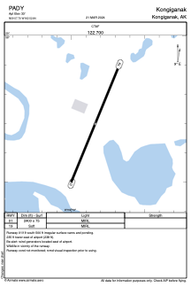
Runways:
| RWY identifier | QFU | Length (ft) | Width (ft) | Surface | LDA (ft) |
| 01 | 21° | 2400 | 75 | OTHER | |
| 19 | 201° | 2400 | 75 | OTHER |
Airport contact information
Address: Kongiganak