


P29 - Tombstone Muni
Located in Tombstone, United States
ICAO - P29, IATA -
Data provided by AirmateGeneral information
Coordinates: N31°40'17" W110°1'17"
Elevation is 4733 feet MSL.
Magnetic variation is 10° East View others Airports in Arizona
Operational data
Special qualification required
Current time UTC:
Current local time:
Weather at : KFHU - Sierra Vista Muni-Libby Aaf ( 32 km )
METAR: KFHU 260655Z AUTO 23005KT 10SM CLR 14/03 A3000 RMK AO2 SLP111 T01370029 402260113
TAF: TAF KFHU 260400Z 2604/2710 25009KT 9999 SKC QNH2997INS WND VRB06KT AFT 2613 BECMG 2617/2618 23012G20KT 9999 SKC 510007 QNH2990INS BECMG 2619/2620 24018G28KT 9999 SKC 520007 QNH2981INS TEMPO 2621/2707 26020G35KT 530005 TX24/2621Z TN07/2612Z
Communications frequencies: [VIEW]
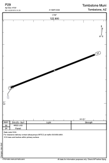
Runways:
| RWY identifier | QFU | Length (ft) | Width (ft) | Surface | LDA (ft) |
| 06 | 69° | 4430 | 60 | ASPH | |
| 24 | 249° | 4430 | 60 | ASPH |
Airport contact information
Address: Tombstone United States