


O24 - Lee Vining
Located in Lee Vining, United States
ICAO - O24, IATA -
Data provided by AirmateGeneral information
Coordinates: N37°57'28" W119°6'21"
Elevation is 6802 feet MSL.
Magnetic variation is 15° East View others Airports in California
Operational data
Special qualification required
Current time UTC:
Current local time:
Weather at : KMMH - Mammoth Yosemite ( 44 km )
METAR: KMMH 242335Z AUTO 25011KT 10SM SCT095 SCT120 13/M11 A3000 RMK AO2 T01321106
TAF: KMMH 242330Z 2500/2524 25012G20KT P6SM VCSH SCT070 BKN100 FM250100 31007KT P6SM VCSH SCT060 FM250600 VRB04KT P6SM SCT030 BKN100 FM251600 24008KT P6SM SCT250 FM252100 27012KT P6SM SCT060 BKN120
Communications frequencies: [VIEW]
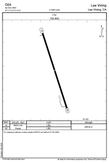
Runways:
| RWY identifier | QFU | Length (ft) | Width (ft) | Surface | LDA (ft) |
| 15 | 162° | 3920 | 60 | ASPH | |
| 33 | 342° | 3920 | 60 | ASPH |
Airport contact information
Address: Lee Vining United States