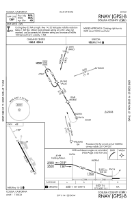


O08 - Colusa County
Located in Colusa, United States
ICAO - O08, IATA -
Data provided by AirmateGeneral information
Coordinates: N39°10'44" W121°59'36"
Elevation is 49 feet MSL.
Magnetic variation is 14° East View others Airports in California
Operational data
Special qualification required
Current time UTC:
Current local time:
Weather at : KMYV - Yuba County ( 38 km )
METAR: KMYV 200753Z AUTO 15006KT 10SM CLR 16/12 A2992 RMK AO2 SLP135 T01610122 402830117
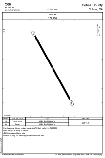
Communications frequencies: [VIEW]
Runways:
| RWY identifier | QFU | Length (ft) | Width (ft) | Surface | LDA (ft) |
| 13 | 151° | 3034 | 59 | ASPH | |
| 31 | 331° | 3034 | 59 | ASPH |
Airport contact information
Address: Colusa United States