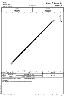


N66 - Albert S Nader Rgnl
Located in Oneonta, United States
ICAO - N66, IATA -
Data provided by AirmateGeneral information
Coordinates: N42°31'29" W75°3'52"
Elevation is 1763 feet MSL.
Magnetic variation is -13° East View others Airports in New York
Operational data
Special qualification required
Current time UTC:
Current local time:
Weather at : KOIC - Lt Warren Eaton ( 38 km )
METAR: KOIC 201135Z AUTO 00000KT 10SM BKN120 07/03 A2998 RMK AO2 T00730034
Communications frequencies: [VIEW]
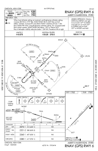
Runways:
| RWY identifier | QFU | Length (ft) | Width (ft) | Surface | LDA (ft) |
| 06 | 44° | 4199 | 75 | ASPH | |
| 24 | 224° | 4199 | 75 | ASPH |
Airport contact information
Address: Oneonta United States