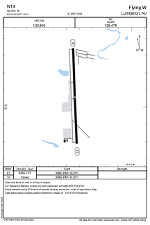


N14 - Flying W
Located in Lumberton, United States
ICAO - N14, IATA -
Data provided by AirmateGeneral information
Coordinates: N39°56'3" W74°48'26"
Elevation is 49 feet MSL.
Magnetic variation is -13° East View others Airports in New Jersey
Operational data
Special qualification required
Current time UTC:
Current local time:
Weather at : KVAY - South Jersey Rgnl ( 3 km )
METAR: KVAY 250654Z AUTO 36005KT 10SM CLR 09/03 A3016 RMK AO2 SLP211 T00940033
Communications frequencies: [VIEW]
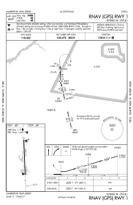
Runways:
| RWY identifier | QFU | Length (ft) | Width (ft) | Surface | LDA (ft) |
| 01 | 358° | 3496 | 75 | ASPH | |
| 19 | 178° | 3496 | 75 | ASPH |
Airport contact information
Address: Lumberton United States
Other aviation service providers
Flight schools

Helicopter Flight Services
Helicopter Flight Services
doug@helicopterflightservices.com+1(609)265-0822