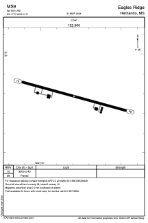


MS9 - Eagles Ridge
Located in Hernando, United States
ICAO - MS9, IATA -
Data provided by AirmateGeneral information
Coordinates: N34°47'47" W89°54'48"
Elevation is 262 feet MSL.
Magnetic variation is 02° East View others Airports in Mississippi
Operational data
Special qualification required
Current time UTC:
Current local time:
Weather at : KOLV - Olive Branch/Taylor Fld ( 23 km )
METAR: KOLV 260435Z AUTO 09007KT 10SM FEW047 BKN050 OVC090 15/11 A3005 RMK A01
Communications frequencies: [VIEW]
Runways:
| RWY identifier | QFU | Length (ft) | Width (ft) | Surface | LDA (ft) |
| 10 | 105° | 3300 | 40 | CONC | |
| 28 | 285° | 3300 | 40 | CONC |
Airport contact information
Address: Hernando United States