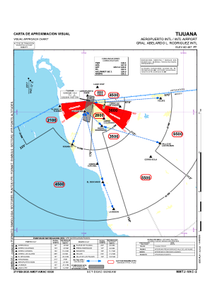
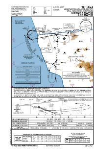
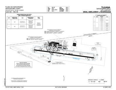


MMTJ - Tijuana Aeropuerto Internacional Gral. Abelardo L. Rodriguez
Located in Tijuana, Mexico
ICAO - MMTJ, IATA - TIJ
Data provided by AirmateGeneral information
Coordinates: N32°32'28" W116°58'12"
Elevation is 487 feet MSL.
View others Airports in Baja California
Operational data
Special qualification required
Current time UTC:
Current local time:
Weather
METAR: MMTJ 271242Z 23004KT 5SM BKN012 OVC017 13/11 A2997 RMK 8/6// HZY
TAF: TAF MMTJ 271133Z 2712/2812 00000KT 6SM HZ BKN015 TX21/2722Z TN12/2712Z TEMPO 2712/2716 4SM -RA BKN010 FM271600 22005KT 6SM HZ SCT020 SCT060 FM272100 26010KT P6SM SKC FM280200 30005KT P6SM SCT020
Communications frequencies: [VIEW]
Runways:
| RWY identifier | QFU | Length (ft) | Width (ft) | Surface | LDA (ft) |
| 09 | 99° | 9715 | 148 | CON | |
| 27 | 279° | 9715 | 148 | CON |
Airport contact information
Address: Tijuana Mexico