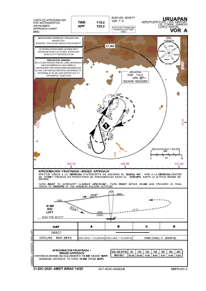
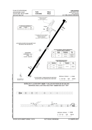


MMPN - Uruapan Aeropuerto Nacional Lic. Y Gral. Ignacio Lopez Rayon
Located in Uruapan, Mexico
ICAO - MMPN, IATA - UPN
Data provided by AirmateGeneral information
Coordinates: N19°23'47" W102°2'20"
Elevation is 5258 feet MSL.
View others Airports in Michoacin
Operational data
Special qualification required
Current time UTC:
Current local time:
Weather
METAR: MMPN 291948Z 00000KT 7SM SCT260 26/10 A3009 RMK 8/001 HZY FU TCU CB W
TAF: TAF MMPN 291647Z 2918/3018 22015KT P6SM SCT280 BECMG 2921/2922 BKN280 FM300300 00000KT P6SM SCT250 FM301200 00000KT P6SM SKC
Communications frequencies: [VIEW]
Runways:
| RWY identifier | QFU | Length (ft) | Width (ft) | Surface | LDA (ft) |
| 02 | 32° | 7874 | 148 | ASP | |
| 20 | 212° | 7874 | 148 | ASP |
Airport contact information
Address: Uruapan Mexico