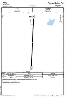


M95 - Richard Arthur Fld
Located in Fayette, United States
ICAO - M95, IATA -
Data provided by AirmateGeneral information
Coordinates: N33°42'33" W87°48'55"
Elevation is 357 feet MSL.
Magnetic variation is -03° East View others Airports in Alabama
Operational data
Special qualification required
Current time UTC:
Current local time:
Weather at : KJFX - Walker County-Bevill Fld ( 51 km )
METAR: KJFX 252155Z AUTO 00000KT 10SM CLR 24/12 A3009 RMK AO2
Communications frequencies: [VIEW]
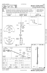
Runways:
| RWY identifier | QFU | Length (ft) | Width (ft) | Surface | LDA (ft) |
| 01 | 3° | 5009 | 80 | ASPH | |
| 19 | 183° | 5009 | 80 | ASPH |
Airport contact information
Address: Fayette United States