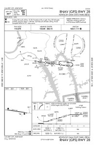
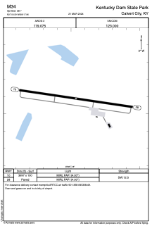


M34 - Kentucky Dam State Park
Located in Calvert City, United States
ICAO - M34, IATA -
Data provided by AirmateGeneral information
Coordinates: N37°0'35" W88°17'58"
Elevation is 351 feet MSL.
Magnetic variation is -03° East View others Airports in Kentucky
Operational data
Special qualification required
Current time UTC:
Current local time:
Weather at : KCEY - Kyle-Oakley Fld ( 39 km )
METAR: KCEY 200935Z AUTO 34004KT 10SM OVC110 10/08 A3023 RMK A01
Communications frequencies: [VIEW]
Runways:
| RWY identifier | QFU | Length (ft) | Width (ft) | Surface | LDA (ft) |
| 10 | 98° | 3996 | 100 | ASPH | |
| 28 | 278° | 3996 | 100 | ASPH |
Airport contact information
Address: Calvert City United States