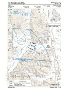
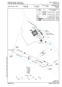


LYSP - Smederevska Palanka / Rudine
Located in Smederevska Palanka, Serbia and Montenegro
ICAO - LYSP, IATA -
Data provided by AirmateGeneral information
Coordinates: N44°21'5" E20°57'36"
Elevation is 337 feet MSL.
Magnetic variation is 5° East View others Airports in Podunavlje
Operational data
Special qualification required
Current time UTC:
Current local time:
Weather at : LYKV - Kraljevo / Morava ( 66 km )
METAR: LYKV 051700Z 12005KT 9999 FEW043 22/09 Q1012 NOSIG
TAF: TAF LYKV 051100Z 0512/0612 14005KT 9999 SCT043 TX25/0612Z TN09/0604Z TEMPO 0512/0515 21015G25KT 4000 TSRA SCT033CB SCT040 BECMG 0600/0602 3000 BR TEMPO 0603/0605 0500 FG BECMG 0605/0607 9999 NSW
Communications frequencies: [VIEW]
Runways:
| RWY identifier | QFU | Length (ft) | Width (ft) | Surface | LDA (ft) |
| 11 | 0° | 2215 | 148 | UNK | |
| 29 | 0° | 2215 | 148 | UNK |
Airport contact information
Address: Smederevska Palanka Serbia and Montenegro