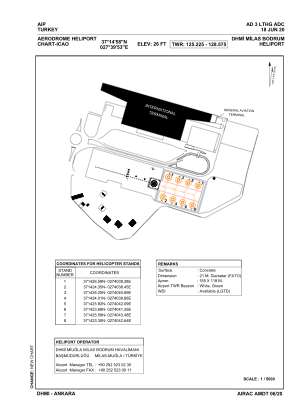


LTHG - Milas Bodrum
Located in Mugla, Turkey
ICAO - , IATA -
Data provided by AirmateGeneral information
Coordinates: N37°14'58" E27°39'53"
Elevation is 26 feet MSL.
Magnetic variation is 4.9° East View others Airports in Mugla
Operational data
Special qualification required
Current time UTC:
Current local time:
Weather at : LTFE - Milas Bodrum ( 0 km )
METAR: LTFE 050850Z 02013KT 350V050 9999 SCT035 23/07 Q1009 NOSIG RMK RWY10 04016KT 350V070
TAF: TAF LTFE 050440Z 0506/0606 VRB02KT 9999 FEW035 SCT100 BECMG 0507/0509 01015KT BECMG 0515/0517 CAVOK BECMG 0517/0519 04005KT
Communications frequencies: [VIEW]
Runways:
Airport contact information
Address: Mugla Turkey