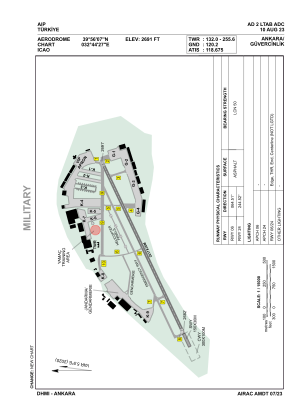


LTAB - Ankara Guvercinlik
Located in Ankara, Turkey
ICAO - LTAB, IATA -
Data provided by AirmateGeneral information
Coordinates: N39°56'7" E32°44'27"
Elevation is 2691 feet MSL.
Magnetic variation is 5.9° East View others Airports in Ankara
Operational data
Special qualification required
Current time UTC:
Current local time:
Weather
TAF: TAF LTAB 041640Z 0418/0503 VRB02KT 9999 SCT040 SCT100 TEMPO 0418/0420 -SHRA BKN035 BKN090
Communications frequencies: [VIEW]
Runways:
| RWY identifier | QFU | Length (ft) | Width (ft) | Surface | LDA (ft) |
| 09 | 90° | 3501 | 98 | ASP | |
| 27 | 270° | 3501 | 98 | ASP | |
| 06 | 65° | 6617 | 118 | ASPH | 6617 |
| 24 | 245° | 6617 | 118 | ASPH | 6617 |
Airport contact information
Address: Ankara Turkey