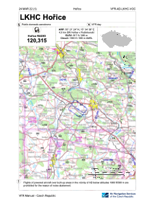


LKHC - Horice
Located in Horice V Podkrkonosi, Czech Republic
ICAO - LKHC, IATA -
Data provided by AirmateGeneral information
Coordinates: N50°21'24" E15°34'38"
Elevation is 917 feet MSL.
View others Airports in Hradec Králové Region
Operational data
Special qualification required
Current time UTC:
Current local time:
Weather at : LKPD - Pardubice ( 40 km )
METAR: LKPD 060530Z 08003KT CAVOK 11/11 Q1010 NOSIG RMK BLU BLU
TAF: TAF LKPD 052300Z 0600/0700 VRB02KT CAVOK TEMPO 0602/0605 1000 BR BECMG 0608/0610 SCT030 TEMPO 0609/0618 30012KT 7000 SHRA SCT025TCU PROB40 TEMPO 0611/0618 5000 TSRA BKN020CB
Communications frequencies: [VIEW]
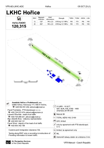
Runways:
| RWY identifier | QFU | Length (ft) | Width (ft) | Surface | LDA (ft) |
| 12 | 0° | 2428 | 75 | UNK | |
| 30 | 0° | 2428 | 75 | UNK |
Airport contact information
Address: Horice V Podkrkonosi Czech Republic
