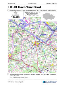


LKHB - Havlickuv Brod
Located in Havlickuv Brod, Czech Republic
ICAO - LKHB, IATA -
Data provided by AirmateGeneral information
Coordinates: N49°35'50" E15°32'57"
Elevation is 1519 feet MSL.
View others Airports in Vysocina Region
Operational data
Special qualification required
Current time UTC:
Current local time:
Weather at : LKCV - Caslav ( 40 km )
METAR: LKCV 070100Z 20001KT 9999 OVC025 13/12 Q1009 NOSIG RMK BLU BLU
TAF: TAF LKCV 062300Z 0700/0800 29006KT 9999 BKN030 BKN070 BECMG 0700/0702 SCT014 BKN020 TEMPO 0700/0715 5000 RA BKN014 OVC020 PROB30 TEMPO 0700/0709 3000 RA BR BKN012
Communications frequencies: [VIEW]
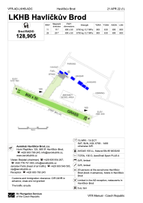
Runways:
| RWY identifier | QFU | Length (ft) | Width (ft) | Surface | LDA (ft) |
| 11 | 0° | 2625 | 164 | UNK | |
| 29 | 0° | 2625 | 164 | UNK |
Airport contact information
Address: Havlickuv Brod Czech Republic