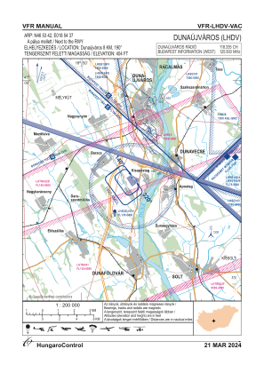
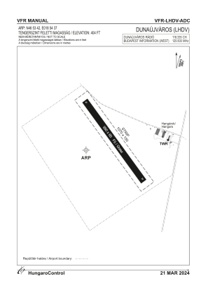


LHDV - Dunaujvaros
Located in Dunaujvaros, Hungary
ICAO - LHDV, IATA -
Data provided by AirmateGeneral information
Coordinates: N46°53'42" E18°54'37"
Elevation is 404 feet MSL.
Magnetic variation is 3.7° East View others Airports in Fejér
Operational data
Special qualification required
Current time UTC:
Current local time:
Weather at : LHKE - Kecskemet ( 64 km )
METAR: LHKE 061715Z 22007KT 190V250 CAVOK 23/11 Q1009 NOSIG RMK BLU
TAF: TAF LHKE 061715Z 0618/0703 20007KT CAVOK TEMPO 0621/0701 22011KT BECMG 0701/0703 26012KT PROB30 TEMPO 0702/0703 8000 -SHRA SCT033TCU BKN060
Communications frequencies: [VIEW]
Runways:
| RWY identifier | QFU | Length (ft) | Width (ft) | Surface | LDA (ft) |
| 14 | 0° | 3117 | 197 | GRASS | |
| 32 | 0° | 3117 | 197 | GRASS |
Airport contact information
Address: Dunaujvaros Hungary