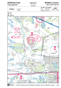


LFPF - Beynes Thiverval
Located in Beynes, France
ICAO - LFPF, IATA -
Data provided by AirmateGeneral information
Coordinates: N48°50'34" E1°54'27"
Elevation is 371 feet MSL.
Magnetic variation is 0.89° East View others Airports in Île-de-France
Operational data
Special qualification required
Current time UTC:
Current local time:
Weather at : LFPN - Toussus Le Noble ( 18 km )
METAR: LFPN 021100Z AUTO 28008KT 250V310 9999 OVC015 12/10 Q1004 NOSIG
TAF: TAF LFPN 020800Z 0209/0218 27014KT 9999 BKN012 BECMG 0211/0213 BKN016 PROB40 TEMPO 0213/0216 27015G25KT
Communications frequencies: [VIEW]
Runways:
| RWY identifier | QFU | Length (ft) | Width (ft) | Surface | LDA (ft) |
| 12 | 115° | 3281 | 262 | GRASS | 3150 |
| 30 | 295° | 3281 | 262 | GRASS | 2887 |
Airport contact information
Address: Beynes France