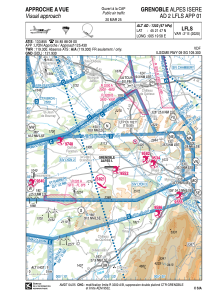
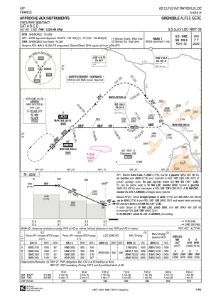
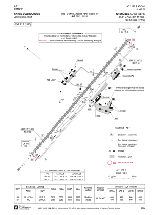


LFLS - Grenoble Alpes Isere
Located in Grenoble, France
ICAO - LFLS, IATA - GNB
Data provided by AirmateGeneral information
Coordinates: N45°21'47" E5°19'58"
Elevation is 1302 feet MSL.
Magnetic variation is 1.95° East View others Airports in Rhône Alpes
Operational data
Special qualification required
Current time UTC:
Current local time:
Weather
TAF: TAF LFLS 300200Z 3003/0103 09005KT CAVOK TEMPO 3003/3008 OVC005 PROB30 TEMPO 3003/3007 0400 FG VV/// BECMG 3010/3012 27005KT SCT040 PROB40 TEMPO 3013/3019 4500 SHRA FEW012 BKN035TCU PROB30 TEMPO 3013/3019 2500 TSRA BKN012 BKN030CB BECMG 3019/3021 09005KT PROB30 TEMPO 3021/3024 0600 BCFG
Communications frequencies: [VIEW]
Runways:
| RWY identifier | QFU | Length (ft) | Width (ft) | Surface | LDA (ft) |
| 09R | 90° | 2953 | 164 | GRASS | |
| 27L | 270° | 2953 | 164 | GRASS | |
| 09 | 90° | 10007 | 148 | ASPH | 10007 |
| 27 | 270° | 10007 | 148 | ASPH | 10007 |
Airport contact information
Address: Grenoble France

