


LFIR - Revel Montgey
Located in , France
ICAO - LFIR, IATA -
Data provided by AirmateGeneral information
Coordinates: N43°28'49" E1°58'44"
Elevation is 643 feet MSL.
Magnetic variation is 1.13° East View others Airports in Midi-Pyrénées
Operational data
Special qualification required
Current time UTC:
Current local time:
Weather at : LFCK - Castres Mazamet ( 26 km )
METAR: LFCK 291230Z AUTO 28007KT 9999 -RA BKN004/// BKN017/// OVC025/// ///CB 12/11 Q1018 TEMPO 3000 -RA OVC004
TAF: TAF AMD LFCK 291215Z 2912/2921 VRB03KT 9999 BKN008 OVC050 TEMPO 2912/2915 3000 -RA OVC004 BECMG 2915/2917 FEW008 BKN016 BKN060 TEMPO 2915/2919 4000 -RA
Communications frequencies: [VIEW]
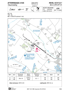
Runways:
| RWY identifier | QFU | Length (ft) | Width (ft) | Surface | LDA (ft) |
| 12 | 126° | 2461 | 59 | ASPH | 2100 |
| 30 | 306° | 2461 | 59 | ASPH | 2461 |
Airport contact information
Address: France
