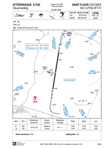


LFHQ - Saint Flour Coltines
Located in Saint Flour, France
ICAO - LFHQ, IATA -
Data provided by AirmateGeneral information
Coordinates: N45°4'30" E2°59'33"
Elevation is 3218 feet MSL.
Magnetic variation is 1.35° East View others Airports in Auvergne
Operational data
Special qualification required
Current time UTC:
Current local time:
Weather at : LFLW - Aurillac ( 49 km )
METAR: LFLW 291600Z AUTO 12009KT 080V140 9999 -RA FEW018/// BKN060/// OVC072/// //////TCU 11/09 Q1018 TEMPO 3000 RA BR BKN014 SCT015TCU
TAF: TAF LFLW 291400Z 2915/2924 12008KT 6000 RA BKN020 OVC040 TEMPO 2915/2924 3000 RA BR BKN014 SCT015TCU
Communications frequencies: [VIEW]
Runways:
| RWY identifier | QFU | Length (ft) | Width (ft) | Surface | LDA (ft) |
| 01 | 9° | 4298 | 98 | ASPH | 4298 |
| 19 | 189° | 4298 | 98 | ASPH | 4298 |
Airport contact information
Address: Saint Flour France
Handlers

Fuel provider

Other aviation service providers
Aviation club (not for profit)

Association des pilotes de Haute Auvergne
Association des pilotes de Haute Auvergne
synd.mixte-gest.aero.coltines@orange.fr+33471609495
Club Rsa Des Volcans St Flour
Club Rsa Des Volcans St Flour
club.rsa.des.volcans@laposte.net0695176920