


LFHI - Morestel
Located in Morestel, France
ICAO - LFHI, IATA -
Data provided by AirmateGeneral information
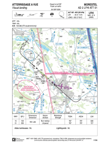
Coordinates: N45°41'13" E5°27'9"
Elevation is 803 feet MSL.
Magnetic variation is 1.98° East View others Airports in Rhône Alpes
Operational data
Special qualification required
Current time UTC:
Current local time:
Communications frequencies: [VIEW]
Runways:
| RWY identifier | QFU | Length (ft) | Width (ft) | Surface | LDA (ft) |
| 13 | 131° | 2582 | 262 | GRASS | 2060 |
| 31 | 311° | 2582 | 262 | GRASS | 2582 |
Airport contact information
Address: Morestel France
