


LFGJ - Dole Tavaux
Located in Dole, France
ICAO - LFGJ, IATA - DLE
Data provided by AirmateGeneral information
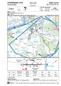
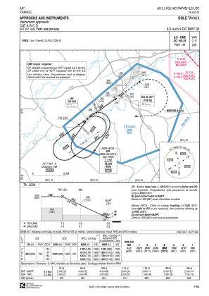
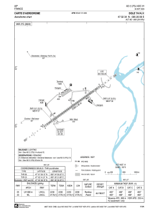
Coordinates: N47°2'34" E5°26'6"
Elevation is 645 feet MSL.
Magnetic variation is 1.96° East View others Airports in Franche-Comté
Operational data
Special qualification required
Current time UTC:
Current local time:
Weather
METAR: LFGJ 031130Z AUTO 23008KT 200V260 9999 FEW036 SCT046 BKN058 14/06 Q1016 TEMPO FEW050CB
TAF: TAF LFGJ 031100Z 0312/0321 23008KT 9999 FEW035 SCT053 TEMPO 0312/0313 FEW035TCU TEMPO 0313/0318 FEW050CB PROB40 TEMPO 0318/0321 3500 SHRA FEW050TCU
Communications frequencies: [VIEW]
Runways:
| RWY identifier | QFU | Length (ft) | Width (ft) | Surface | LDA (ft) |
| 05 | 54° | 7316 | 148 | MACADAM | 7316 |
| 23 | 234° | 7316 | 148 | MACADAM | 7136 |
Airport contact information
Address: Dole France

