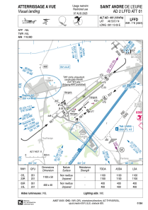


LFFD - Saint Andre De L'eure
Located in , France
ICAO - LFFD, IATA -
Data provided by AirmateGeneral information
Coordinates: N48°53'51" E1°15'3"
Elevation is 491 feet MSL.
Magnetic variation is 0.68° East View others Airports in Upper Normandy
Operational data
Special qualification required
Current time UTC:
Current local time:
Weather at : LFOE - Evreux Fauville ( 15 km )
METAR: LFOE 272330Z AUTO 17011KT 9999 SCT022 BKN066 OVC078 10/09 Q1000 BECMG RA BKN010
TAF: TAF LFOE 272000Z 2721/2821 15007KT 7000 RA SCT045 BKN050 BECMG 2722/2724 BKN010 BECMG 2802/2804 20015G25KT BKN015 TEMPO 2813/2818 4000 SHRA BKN020CB BECMG 2818/2819 14003KT
Communications frequencies: [VIEW]
Runways:
| RWY identifier | QFU | Length (ft) | Width (ft) | Surface | LDA (ft) |
| 05L | 52° | 3609 | 164 | GRASS | 3609 |
| 23R | 232° | 3609 | 164 | GRASS | 3609 |
| 05R | 52° | 1312 | 131 | GRASS | 1312 |
| 23L | 232° | 1312 | 131 | GRASS | 1312 |
Airport contact information
Address: France


