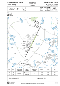


LFEP - Pouilly Maconge
Located in Pouilly-En-Auxois, France
ICAO - LFEP, IATA -
Data provided by AirmateGeneral information
Coordinates: N47°13'14" E4°33'37"
Elevation is 1413 feet MSL.
Magnetic variation is 1.72° East View others Airports in Burgundy
Operational data
Special qualification required
Current time UTC:
Current local time:
Weather at : LFSD - Dijon-Longvic ( 41 km )
METAR: LFSD 022300Z AUTO 21005KT 180V240 CAVOK 09/08 Q1013
Communications frequencies: [VIEW]
Runways:
| RWY identifier | QFU | Length (ft) | Width (ft) | Surface | LDA (ft) |
| 03 | 27° | 2789 | 164 | GRASS | 2789 |
| 21 | 207° | 2789 | 164 | GRASS | 2789 |
Airport contact information
Address: Pouilly-En-Auxois France
