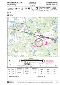


LFDS - Sarlat Domme
Located in Sarlat, France
ICAO - LFDS, IATA - XSL
Data provided by AirmateGeneral information
Coordinates: N44°47'32" E1°14'37"
Elevation is 979 feet MSL.
Magnetic variation is 0.89° East View others Airports in Aquitaine
Operational data
Special qualification required
Current time UTC:
Current local time:
Weather at : LFSL - Brive Souillac ( 33 km )
METAR: LFSL 042300Z AUTO 12004KT 9999 ///TCU 13/12 Q1013
Communications frequencies: [VIEW]
Runways:
| RWY identifier | QFU | Length (ft) | Width (ft) | Surface | LDA (ft) |
| 10 | 104° | 2444 | 66 | ASPH | 2444 |
| 28 | 284° | 2444 | 66 | ASPH | 2444 |
Airport contact information
Address: Sarlat France


