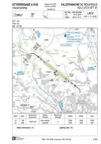


LFCV - Villefranche De Rouergue
Located in Villefranche De Rouergue, France
ICAO - LFCV, IATA -
Data provided by AirmateGeneral information
Coordinates: N44°22'8" E2°1'37"
Elevation is 1104 feet MSL.
Magnetic variation is 1.12° East View others Airports in Midi-Pyrénées
Operational data
Special qualification required
Current time UTC:
Current local time:
Weather at : LFCR - Rodez Aveyron ( 36 km )
METAR: LFCR 290930Z AUTO 08003KT 7000 -RA BKN003/// BKN012/// BKN019/// //////TCU 10/10 Q1018 TEMPO 4000 RA BKN003
TAF: TAF LFCR 290500Z 2906/3006 VRB03KT 9999 BKN040 TEMPO 2906/3006 -RA BKN020 PROB40 TEMPO 2906/2912 4000 RA BKN003 BECMG 2911/2913 13008KT BECMG 2922/2924 VRB03KT
Communications frequencies: [VIEW]
Runways:
| RWY identifier | QFU | Length (ft) | Width (ft) | Surface | LDA (ft) |
| 13 | 129° | 3379 | 262 | GRASS | 3379 |
| 31 | 309° | 3379 | 262 | GRASS | 3133 |
Airport contact information
Address: Villefranche De Rouergue France