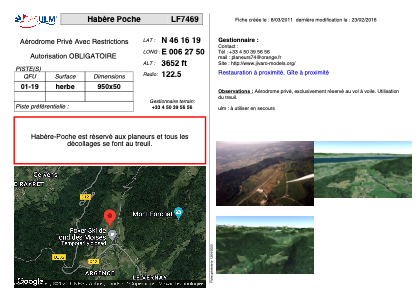


LF7469 - Habère Poche
Located in Habère-Poche, France
ICAO - , IATA -
Data provided by AirmateGeneral information
Coordinates: N46°16'19" E6°27'50"
Elevation is 3652 feet MSL.
View others Airports in Rhône Alpes
Operational data
Special qualification required
Current time UTC:
Current local time:
Weather at : LSGG - Geneve ( 27 km )
METAR: LSGG 300450Z VRB01KT 9000 MIFG NSC 07/07 Q1016 NOSIG
TAF: TAF AMD LSGG 300325Z 3003/0109 VRB02KT 8000 NSC TX20/3015Z TN09/3005Z TN11/0105Z PROB30 TEMPO 3003/3004 4500 BR BECMG 3004/3006 CAVOK
Communications frequencies: [VIEW]
Runways:
| RWY identifier | QFU | Length (ft) | Width (ft) | Surface | LDA (ft) |
| 01 | 0° | 3116 | 164 | GRASS | |
| 19 | 0° | 3116 | 164 | GRASS |
Airport contact information
Address: Habère-Poche France