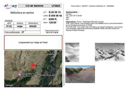


LF3825 - Col de Sarenne
Located in Clavans en Haut Oisans, France
ICAO - , IATA -
Data provided by AirmateGeneral information
Coordinates: N45°5'15" E6°8'45"
Elevation is 6500 feet MSL.
View others Airports in Rhône Alpes
Operational data
Special qualification required
Current time UTC:
Current local time:
Weather at : LFLB - Chambery Aix Les Bains ( 65 km )
METAR: LFLB 300030Z AUTO VRB02KT 8000 OVC014 10/09 Q1018
TAF: TAF LFLB 291400Z 2915/3015 36008KT CAVOK PROB40 TEMPO 2915/2918 -SHRA FEW040CB SCT045TCU BECMG 2918/2920 VRB02KT PROB40 TEMPO 3001/3008 4000 BR BKN006 PROB30 TEMPO 3001/3007 0500 FG VV/// BECMG 3009/3011 36005KT PROB30 TEMPO 3013/3015 SHRA FEW040CB SCT050TCU
Communications frequencies: [VIEW]
Runways:
| RWY identifier | QFU | Length (ft) | Width (ft) | Surface | LDA (ft) |
| 07 | 0° | 1968 | 196 | SNOW | |
| 25 | 0° | 1968 | 196 | SNOW |
Airport contact information
Address: Clavans en Haut Oisans France