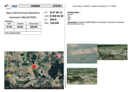


LF3761 - Lémeré
Located in Lémeré, France
ICAO - , IATA -
Data provided by AirmateGeneral information
Coordinates: N47°5'12" E0°20'35"
Elevation is 300 feet MSL.
View others Airports in Poitou-Charentes
Operational data
Special qualification required
Current time UTC:
Current local time:
Weather at : LFOT - Tours Val De Loire ( 48 km )
METAR: LFOT 061130Z AUTO 19011KT 160V230 9999 BKN042 BKN054 BKN066 16/08 Q1009 TEMPO 20015G25KT 2500 -TSRA BKN020CB
TAF: TAF LFOT 061100Z 0612/0712 21010KT 9999 BKN020 TEMPO 0612/0621 4000 SHRA BKN025 PROB40 TEMPO 0612/0618 20015G25KT 2500 SHRA BKN020CB PROB40 TEMPO 0613/0618 -TSRA BECMG 0621/0624 29005KT BKN014 PROB40 TEMPO 0621/0708 4000 SHRA BKN012TCU PROB30 TEMPO 0623/0701 2500 SHRA BKN007CB PROB30 TEMPO 0702/0708 2500 BR BKN004 BECMG 0708/0711 35010KT BKN020 PROB30 TEMPO 0709/0712 -SHRA
Communications frequencies: [VIEW]
Runways:
| RWY identifier | QFU | Length (ft) | Width (ft) | Surface | LDA (ft) |
| 07 | 0° | 738 | 82 | GRASS | |
| 25 | 0° | 738 | 82 | GRASS |
Airport contact information
Address: Lémeré France