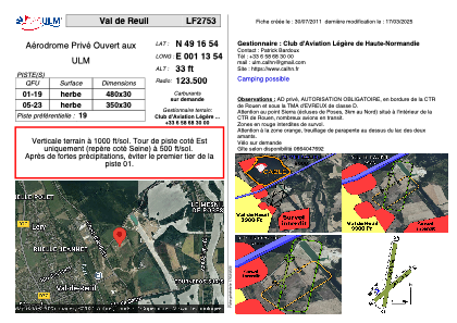


LF2753 - Val de Reuil
Located in Val-de-Reuil, France
ICAO - , IATA -
Data provided by AirmateGeneral information
Coordinates: N49°16'53" E1°13'53"
Elevation is 33 feet MSL.
View others Airports in Upper Normandy
Operational data
Special qualification required
Current time UTC:
Current local time:
Weather at : LFOP - Rouen Vallee De Seine ( 13 km )
METAR: LFOP 271400Z AUTO 10009KT 7000 -RA SCT009/// BKN027/// BKN043/// ///CB 12/11 Q1000 TEMPO VRB15G25KT 1000 TSRA BKN008 BKN015CB
TAF: TAF LFOP 271100Z 2712/2721 14010KT 9999 BKN020 TEMPO 2712/2721 VRB15G25KT 3000 RA BKN008 BKN015CB PROB30 TEMPO 2715/2720 1000 TSRA
Communications frequencies: [VIEW]
Runways:
| RWY identifier | QFU | Length (ft) | Width (ft) | Surface | LDA (ft) |
| 01 | 0° | 1640 | 164 | GRASS | |
| 19 | 0° | 1640 | 164 | GRASS |
Airport contact information
Address: Val-de-Reuil France
Web: https://www.calhn.fr