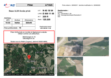


LF1625 - Pillac
Located in Pillac, France
ICAO - , IATA -
Data provided by AirmateGeneral information
Coordinates: N45°19'54" E0°11'5"
Elevation is 335 feet MSL.
View others Airports in Aquitaine
Operational data
Special qualification required
Current time UTC:
Current local time:
Weather at : LFBU - Angouleme Brie Champniers ( 44 km )
METAR: LFBU 042200Z AUTO 23007KT 190V250 9999 -RA OVC007/// ///CB 15/14 Q1013
TAF: TAF LFBU 041700Z 0418/0518 20010KT 9999 BKN040 TEMPO 0418/0423 2000 RA OVC005 TEMPO 0423/0508 3000 BR BKN005 PROB30 TEMPO 0500/0503 0400 FG VV/// BECMG 0509/0511 BKN020TCU TEMPO 0513/0516 20010G20KT 4000 SHRA BKN020TCU PROB30 TEMPO 0513/0515 1000 -TSRAGS BKN015CB BECMG 0515/0517 27010KT
Communications frequencies: [VIEW]
Runways:
| RWY identifier | QFU | Length (ft) | Width (ft) | Surface | LDA (ft) |
| 15 | 0° | 1049 | 131 | GRASS | |
| 33 | 0° | 1049 | 131 | GRASS |
Airport contact information
Address: Pillac France