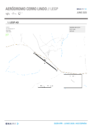


LEGP - Cerro Lindo (Caceres)
Located in Monroy, Spain
ICAO - , IATA -
Data provided by AirmateGeneral information
Coordinates: N39°35'42" W6°12'30"
Elevation is 1246 feet MSL.
Magnetic variation is -1° East View others Airports in Extremadura
Operational data
Special qualification required
Current time UTC:
Current local time:
Weather at : - ( 0 km )
METAR: YPGV 200122Z AUTO 14018KT 9999 // SCT012 BKN019 BKN047 26/24 Q1009
Communications frequencies: [VIEW]
Runways:
| RWY identifier | QFU | Length (ft) | Width (ft) | Surface | LDA (ft) |
| 13 | 126° | 2665 | 58 | ASPH | |
| 31 | 306° | 2665 | 58 | ASPH |
Airport contact information
Address: Monroy Spain