


L39 - Leesville
Located in Leesville, United States
ICAO - L39, IATA -
Data provided by AirmateGeneral information
Coordinates: N31°10'5" W93°20'33"
Elevation is 282 feet MSL.
Magnetic variation is 02° East View others Airports in Louisiana
Operational data
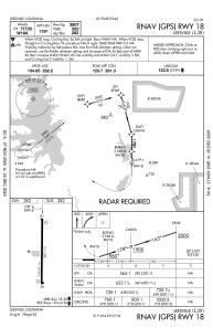
Special qualification required
Current time UTC:
Current local time:
Weather at : KPOE - Polk Aaf ( 20 km )
METAR: KPOE 230555Z AUTO 00000KT 10SM CLR 10/08 A3013 RMK AO2 LTG DSNT N SLP205 T01040083 10207 20104 402200070 56003
TAF: TAF KPOE 222300Z 2223/2405 VRB06KT 9999 SKC QNH3013INS BECMG 2304/2305 15006KT 9999 SKC QNH3014INS BECMG 2314/2315 18009KT 9999 SKC QNH3014INS TX26/2321Z TN08/2312Z LAST NO AMDS AFT 2305 NEXT 2315
Communications frequencies: [VIEW]
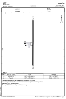
Runways:
| RWY identifier | QFU | Length (ft) | Width (ft) | Surface | LDA (ft) |
| 18 | 180° | 3807 | 75 | ASPH | |
| 36 | 360° | 3807 | 75 | ASPH |
Airport contact information
Address: Leesville United States