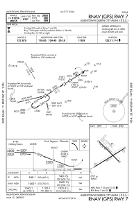
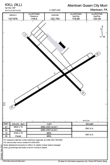


KXLL - Allentown Queen City Muni
Located in Allentown, United States
ICAO - XLL, IATA -
Data provided by AirmateGeneral information
Coordinates: N40°34'13" W75°29'18"
Elevation is 399 feet MSL.
Magnetic variation is -12° East View others Airports in Pennsylvania
Operational data
Special qualification required
Current time UTC:
Current local time:
Weather
METAR: KXLL 191815Z AUTO 16006KT 10SM OVC022 12/06 A3009 RMK AO2
Communications frequencies: [VIEW]
Runways:
| RWY identifier | QFU | Length (ft) | Width (ft) | Surface | LDA (ft) |
| 07 | 58° | 3950 | 75 | ASPH | |
| 25 | 238° | 3950 | 75 | ASPH | |
| 15 | 135° | 3160 | 75 | ASPH | |
| 33 | 315° | 3160 | 75 | ASPH |
Airport contact information
Address: Allentown United States
