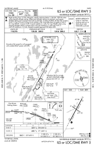


KWVL - Waterville Robert Lafleur
Located in Waterville, United States
ICAO - WVL, IATA - WVL
Data provided by AirmateGeneral information
Coordinates: N44°31'60" W69°40'32"
Elevation is 332 feet MSL.
Magnetic variation is -18° East View others Airports in Maine
Operational data
Special qualification required
Current time UTC:
Current local time:
Weather
METAR: KWVL 192356Z AUTO 20006KT 10SM CLR 08/00 A3003 RMK AO2 SLP196 T00830000 10139 20083 55004
Communications frequencies: [VIEW]
Runways:
| RWY identifier | QFU | Length (ft) | Width (ft) | Surface | LDA (ft) |
| 05 | 29° | 5500 | 100 | ASPH | |
| 23 | 209° | 5500 | 100 | ASPH | |
| 14 | 125° | 2301 | 60 | ASPH | |
| 32 | 305° | 2301 | 60 | ASPH |
Airport contact information
Address: Waterville United States
