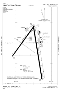


KVLD - Valdosta Rgnl
Located in Valdosta, United States
ICAO - VLD, IATA - VLD
Data provided by AirmateGeneral information
Coordinates: N30°46'53" W83°16'34"
Elevation is 203 feet MSL.
Magnetic variation is -05° East View others Airports in Georgia
Operational data
Special qualification required
Current time UTC:
Current local time:
Weather
TAF: KVLD 241720Z 2418/2518 22004KT P6SM SCT040 FM251400 34003KT P6SM SKC
Communications frequencies: [VIEW]
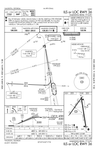
Runways:
| RWY identifier | QFU | Length (ft) | Width (ft) | Surface | LDA (ft) |
| 04 | 36° | 5598 | 100 | ASPH | |
| 22 | 216° | 5598 | 100 | ASPH | |
| 13 | 126° | 3636 | 75 | ASPH | |
| 31 | 306° | 3636 | 75 | ASPH | |
| 17 | 171° | 8002 | 150 | ASPH | |
| 35 | 351° | 8002 | 150 | ASPH |
Airport contact information
Address: Valdosta United States
