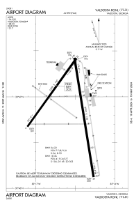


KVLD - Valdosta Rgnl
Located in Valdosta, United States
ICAO - VLD, IATA - VLD
Data provided by AirmateGeneral information
Coordinates: N30°46'53" W83°16'33"
Elevation is 203 feet MSL.
Magnetic variation is -05° East View others Airports in Georgia
Operational data
Special qualification required
Current time UTC:
Current local time:
Weather
METAR: KVLD 082353Z 21005KT 10SM CLR 28/21 A2985 RMK AO2 SLP114 T02830206 10339 20283 56003
TAF: KVLD 082344Z 0900/0924 19003KT P6SM SCT250 FM090500 20003KT 6SM BR BKN009 FM090900 18004KT 1SM BR BKN004 TEMPO 0911/0913 1/2SM FG VV002 FM091400 23005KT P6SM SCT015 BKN025 FM091600 21008KT P6SM SCT025 BKN035 FM092000 22008KT P6SM VCTS SCT035CB BKN045
Communications frequencies: [VIEW]
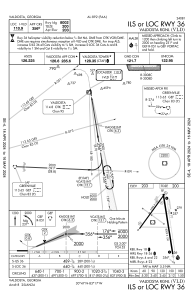
Runways:
| RWY identifier | QFU | Length (ft) | Width (ft) | Surface | LDA (ft) |
| 04 | 36° | 5598 | 100 | ASPH | |
| 22 | 216° | 5598 | 100 | ASPH | |
| 18 | 171° | 8002 | 150 | ASPH | |
| 36 | 351° | 8002 | 150 | ASPH |
Airport contact information
Address: Valdosta United States
