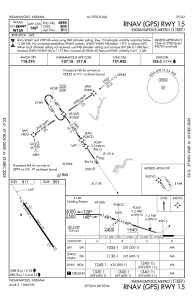
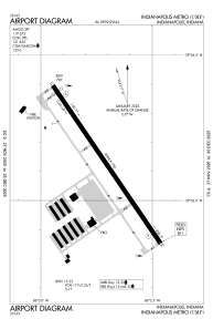


KUMP - Indianapolis Metro
Located in Indianapolis, United States
ICAO - UMP, IATA -
Data provided by AirmateGeneral information
Coordinates: N39°56'7" W86°2'42"
Elevation is 811 feet MSL.
Magnetic variation is -03° East View others Airports in Indiana
Operational data
Special qualification required
Current time UTC:
Current local time:
Weather at : KMQJ - Indianapolis Rgnl ( 16 km )
METAR: KMQJ 190135Z AUTO 12006KT 10SM CLR 21/11 A2989 RMK AO2 LTG DSNT W T02080110
Communications frequencies: [VIEW]
Runways:
| RWY identifier | QFU | Length (ft) | Width (ft) | Surface | LDA (ft) |
| 15 | 146° | 4004 | 100 | ASPH | |
| 33 | 326° | 4004 | 100 | ASPH |
Airport contact information
Address: Indianapolis United States

