


KTYR - Tyler Pounds Rgnl
Located in Tyler, United States
ICAO - TYR, IATA - TYR
Data provided by AirmateGeneral information
Coordinates: N32°21'13" W95°24'11"
Elevation is 544 feet MSL.
Magnetic variation is 03° East View others Airports in Texas
Operational data
Special qualification required
Current time UTC:
Current local time:
Weather
METAR: KTYR 190853Z AUTO 35006KT 10SM OVC016 20/14 A2998 RMK AO2 SLP146 T02000144 51007
TAF: KTYR 190538Z 1906/2006 19010KT P6SM VCSH BKN040 FM190900 34005KT P6SM OVC010 FM191200 01006KT 5SM BR OVC007 FM191500 02007KT P6SM OVC015 FM191800 02008KT 6SM BR OVC015 FM200000 05007KT 4SM BR OVC007 FM200300 04008KT 4SM BR OVC004
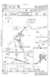
Communications frequencies: [VIEW]
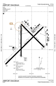
Runways:
| RWY identifier | QFU | Length (ft) | Width (ft) | Surface | LDA (ft) |
| 04 | 45° | 8334 | 150 | CONC | 7734 |
| 22 | 225° | 8334 | 150 | CONC | 7734 |
| 13 | 135° | 5198 | 150 | ASPH | 5198 |
| 31 | 315° | 5198 | 150 | ASPH | 5198 |
| 18 | 180° | 4832 | 150 | ASPH | 4832 |
| 36 | 0° | 4832 | 150 | ASPH | 4832 |
Airport contact information
Address: Tyler United States
