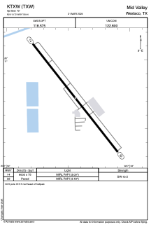


KTXW - Mid Valley
Located in Weslaco, United States
ICAO - TXW, IATA -
Data provided by AirmateGeneral information
Coordinates: N26°10'43" W97°58'26"
Elevation is 70 feet MSL.
Magnetic variation is 04° East View others Airports in Texas
Operational data
Special qualification required
Current time UTC:
Current local time:
Weather
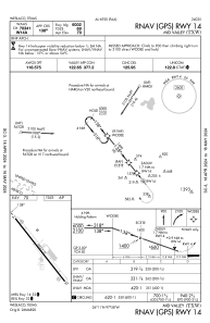
METAR: KTXW 201155Z AUTO 12004KT 10SM SCT014 SCT021 BKN026 25/23 A2995 RMK AO2 T02540226 10254 20246
Communications frequencies: [VIEW]
Runways:
| RWY identifier | QFU | Length (ft) | Width (ft) | Surface | LDA (ft) |
| 14 | 142° | 6002 | 75 | ASPH | |
| 32 | 322° | 6002 | 75 | ASPH |
Airport contact information
Address: Weslaco United States