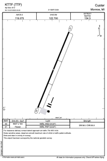


KTTF - Custer
Located in Monroe, United States
ICAO - TTF, IATA -
Data provided by AirmateGeneral information
Coordinates: N41°56'24" W83°26'5"
Elevation is 615 feet MSL.
Magnetic variation is -05° East View others Airports in Michigan
Operational data
Special qualification required
Current time UTC:
Current local time:
Communications frequencies: [VIEW]
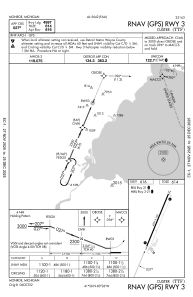
Runways:
| RWY identifier | QFU | Length (ft) | Width (ft) | Surface | LDA (ft) |
| 03 | 22° | 4997 | 100 | ASPH | |
| 21 | 202° | 4997 | 100 | ASPH |
Airport contact information
Address: Monroe United States
Other aviation service providers
Flight schools

Monroe Aviation School Of Flight
Monroe Aviation School Of Flight
jerry@netmichigan.net+1(734)384-9616