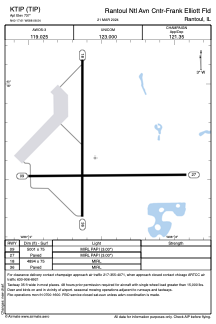


KTIP - Rantoul Ntl Avn Cntr-Frank Elliott Fld
Located in Rantoul, United States
ICAO - TIP, IATA -
Data provided by AirmateGeneral information
Coordinates: N40°17'37" W88°8'33"
Elevation is 737 feet MSL.
Magnetic variation is -01° East View others Airports in Illinois
Operational data
Special qualification required
Current time UTC:
Current local time:
Weather
METAR: KTIP 260755Z AUTO 09008KT 10SM CLR 07/02 A3013 RMK AO2 T00720021
Communications frequencies: [VIEW]
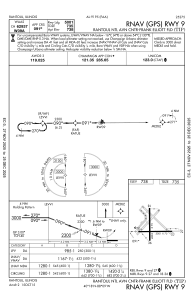
Runways:
| RWY identifier | QFU | Length (ft) | Width (ft) | Surface | LDA (ft) |
| 09 | 90° | 5001 | 75 | ASPH | |
| 27 | 270° | 5001 | 75 | ASPH | |
| 18 | 180° | 4894 | 75 | ASPH | |
| 36 | 360° | 4894 | 75 | ASPH |
Airport contact information
Address: Rantoul United States