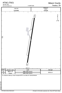


KTGC - Gibson County
Located in Trenton, United States
ICAO - TGC, IATA -
Data provided by AirmateGeneral information
Coordinates: N35°55'57" W88°50'56"
Elevation is 358 feet MSL.
Magnetic variation is -02° East View others Airports in Tennessee
Operational data
Special qualification required
Current time UTC:
Current local time:
Weather at : KMKL - Mc Kellar-Sipes Rgnl ( 37 km )
METAR: KMKL 232153Z 22014G26KT 10SM CLR 24/05 A2999 RMK AO2 PK WND 23026/2121 SLP154 T02440050 $
TAF: KMKL 231720Z 2318/2418 20012G23KT P6SM FEW220 FM240100 22010KT P6SM SCT250 FM240700 26010KT P6SM VCSH BKN050 FM241200 35008KT P6SM BKN050
Communications frequencies: [VIEW]
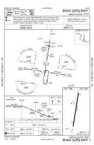
Runways:
| RWY identifier | QFU | Length (ft) | Width (ft) | Surface | LDA (ft) |
| 01 | 9° | 4802 | 75 | ASPH | |
| 19 | 189° | 4802 | 75 | ASPH |
Airport contact information
Address: Trenton United States