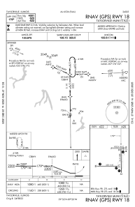
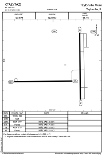


KTAZ - Taylorville Muni
Located in Taylorville, United States
ICAO - TAZ, IATA -
Data provided by AirmateGeneral information
Coordinates: N39°31'57" W89°19'51"
Elevation is 622 feet MSL.
Magnetic variation is 00° East View others Airports in Illinois
Operational data
Special qualification required
Current time UTC:
Current local time:
Weather
METAR: KTAZ 261920Z AUTO 7SM -RA SCT031 SCT050 OVC065 15/13 A2995 RMK AO2 P0003
Communications frequencies: [VIEW]
Runways:
| RWY identifier | QFU | Length (ft) | Width (ft) | Surface | LDA (ft) |
| 18 | 179° | 4001 | 75 | ASPH | |
| 36 | 359° | 4001 | 75 | ASPH | |
| 09L | 90° | 1933 | 165 | GRASS | |
| 27R | 270° | 1933 | 165 | GRASS | |
| 09R | 90° | 3501 | 60 | ASPH | |
| 27L | 270° | 3501 | 60 | ASPH |
Airport contact information
Address: Taylorville United States