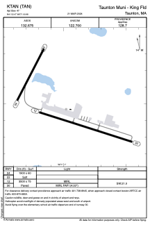


KTAN - Taunton Muni - King Fld
Located in Taunton, United States
ICAO - TAN, IATA -
Data provided by AirmateGeneral information
Coordinates: N41°52'28" W71°0'59"
Elevation is 41 feet MSL.
Magnetic variation is -16° East View others Airports in Massachusetts
Operational data
Special qualification required
Current time UTC:
Current local time:
Weather
METAR: KTAN 240152Z AUTO 00000KT 10SM CLR 06/M01 A3004 RMK AO2 SLP174 T00611011
Communications frequencies: [VIEW]
Runways:
| RWY identifier | QFU | Length (ft) | Width (ft) | Surface | LDA (ft) |
| 04 | 27° | 1900 | 60 | OTHER | |
| 22 | 207° | 1900 | 60 | OTHER | |
| 12 | 108° | 3500 | 75 | ASPH | |
| 30 | 288° | 3500 | 75 | ASPH |
Airport contact information
Address: Taunton United States