


KSYV - Sylvester
Located in Sylvester, United States
ICAO - SYV, IATA -
Data provided by AirmateGeneral information
Coordinates: N31°33'26" W83°53'39"
Elevation is 403 feet MSL.
Magnetic variation is -02° East View others Airports in Georgia
Operational data
Special qualification required
Current time UTC:
Current local time:
Weather at : KABY - Southwest Georgia Rgnl ( 29 km )
METAR: KABY 241153Z 00000KT 7SM CLR 11/09 A3017 RMK AO2 SLP216 T01110089 10122 20089 53008
TAF: KABY 241120Z 2412/2512 00000KT P6SM SKC TEMPO 2412/2413 5SM BR FM241600 25006KT P6SM SCT045
Communications frequencies: [VIEW]
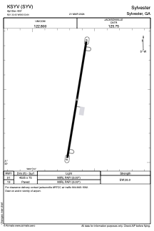
Runways:
| RWY identifier | QFU | Length (ft) | Width (ft) | Surface | LDA (ft) |
| 01 | 10° | 4525 | 75 | ASPH | |
| 19 | 190° | 4525 | 75 | ASPH |
Airport contact information
Address: Sylvester United States