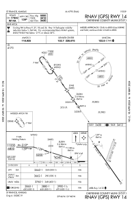
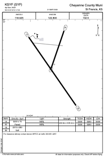


KSYF - Cheyenne County Muni
Located in St Francis, United States
ICAO - SYF, IATA -
Data provided by AirmateGeneral information
Coordinates: N39°45'33" W101°47'41"
Elevation is 3429 feet MSL.
Magnetic variation is 06° East View others Airports in Kansas
Operational data
Special qualification required
Current time UTC:
Current local time:
Weather
METAR: KSYF 261855Z AUTO 31019G26KT 10SM SCT030 BKN042 BKN050 15/08 A2952 RMK AO2 T01500083 PWINO
Communications frequencies: [VIEW]
Runways:
| RWY identifier | QFU | Length (ft) | Width (ft) | Surface | LDA (ft) |
| 18 | 199° | 2313 | 280 | GRASS | |
| 36 | 19° | 2313 | 280 | GRASS | |
| 14 | 145° | 5200 | 75 | CONC | 5000 |
| 32 | 325° | 5200 | 75 | CONC | 5200 |
Airport contact information
Address: St Francis United States
