


KSTL - St Louis Lambert Intl
Located in St Louis, United States
ICAO - STL, IATA - STL
Data provided by AirmateGeneral information
Coordinates: N38°44'55" W90°22'12"
Elevation is 617 feet MSL.
Magnetic variation is -01° East View others Airports in Missouri
Operational data
Special qualification required
Current time UTC:
Current local time:
Weather
METAR: KSTL 200151Z 35005KT 10SM FEW100 BKN250 12/01 A3021 RMK AO2 SLP233 T01220011
TAF: KSTL 192320Z 2000/2106 35007KT P6SM BKN100 FM201700 31012G20KT P6SM SCT070
Communications frequencies: [VIEW]
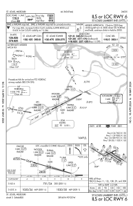
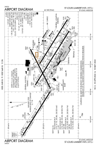
Runways:
| RWY identifier | QFU | Length (ft) | Width (ft) | Surface | LDA (ft) |
| 06 | 63° | 7603 | 150 | CONC | 7323 |
| 24 | 243° | 7603 | 150 | CONC | 7603 |
| 11 | 122° | 9000 | 150 | CONC | 9000 |
| 29 | 302° | 9000 | 150 | CONC | 9000 |
| 12R | 122° | 11020 | 200 | CONC | 10553 |
| 30L | 302° | 11020 | 200 | CONC | 10679 |
| 12L | 122° | 9013 | 150 | CONC | 8956 |
| 30R | 302° | 9013 | 150 | CONC | 9013 |
Airport contact information
Address: St Louis United States
