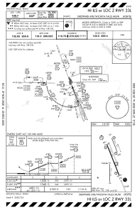
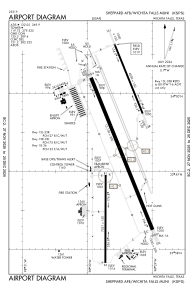


KSPS - Sheppard Afb/Wichita Falls Muni
Located in Wichita Falls, United States
ICAO - SPS, IATA - SPS
Data provided by AirmateGeneral information
Coordinates: N33°59'20" W98°29'31"
Elevation is 1019 feet MSL.
Magnetic variation is 05° East View others Airports in Texas
Operational data
Special qualification required
Current time UTC:
Current local time:
Weather
METAR: KSPS 241152Z 05008KT 8SM BKN008 OVC040 17/17 A3006 RMK AO2 SLP168 T01720167 10189 20167 53022
Communications frequencies: [VIEW]
Runways:
| RWY identifier | QFU | Length (ft) | Width (ft) | Surface | LDA (ft) |
| 15C | 158° | 10003 | 150 | OTHER | |
| 33C | 338° | 10003 | 150 | OTHER | |
| 15R | 158° | 13101 | 300 | CONC | |
| 33L | 338° | 13101 | 300 | CONC | |
| 15L | 158° | 6000 | 150 | OTHER | |
| 33R | 338° | 6000 | 150 | OTHER | |
| 18 | 180° | 7021 | 150 | ASPH | |
| 36 | 0° | 7021 | 150 | ASPH |
Airport contact information
Address: Wichita Falls United States